


NHC Offshore Waters Forecasts
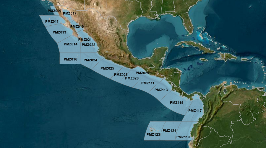
Hover to view popup zone forecast; click a zone to view related text forecast below. Show All Text Below
East Pacific within 250 nm of Mexico (OFFPZ7)
000
FZPN27 KNHC 190314
OFFPZ7

Offshore Waters Forecast
NWS National Hurricane Center Miami, FL
814 PM PDT Sat May 18 2024

Offshore Waters Forecast for the E Pacific within 250 nm of
Mexico

Seas given as significant wave height, which is the average
height of the highest 1/3 of the waves. Individual waves may be
more than twice the significant wave height.
Synopsis for the E Pacific within 250 nm of Mexico
PMZ001-191515-
Synopsis for the E Pacific within 250 nm of Mexico
814 PM PDT Sat May 18 2024

.SYNOPSIS...A surface ridge over the waters west of the Baja
California peninsula along with lower pressures over Mexico will
continue to support moderate to fresh NW to N winds over the
offshore waters of Baja Peninsula today, increasing to locally
strong speeds between Cabo San Lucas and Punta Eugenia tonight
through Mon night. Large NW swell is forecast to impact the outer
waters of Baja California Norte beginning on Mon. Seas of 8 to 9
ft are likely expected N of Punta Eugenia through mid- week.
Disorganized showers located a couple hundred miles to the south
of the coast of southern Mexico have diminished. Environmental
conditions in the area have become unfavorable, and development
of this system is not expected.
PMZ009 Zone Forecast
PMZ009-191515-
Mexico Border S to 30N within 60 nm of shore-
814 PM PDT Sat May 18 2024

.TONIGHT...NW winds 10 to 15 kt. Seas 4 to 6 ft. Period
19 seconds.
.SUN...NW winds 10 to 15 kt N of 31N, and NW 15 to 20 kt S of
31N. Seas 4 to 6 ft. Period 18 seconds.
.SUN NIGHT...NW winds 10 to 15 kt. Seas 4 to 6 ft. Period
18 seconds.
.MON...NW winds 10 to 15 kt. Seas 4 to 6 ft. Period 17 seconds.
.MON NIGHT...NW winds 10 to 15 kt N of 31N, and NW 15 to 20 kt S
of 31N. Seas 5 to 7 ft in NW swell. Period 17 seconds.
.TUE...W to NW winds 10 to 15 kt N of 31N, and NW 15 to 20 kt S
of 31N. Seas 6 to 8 ft in NW swell. Period 17 seconds.
.TUE NIGHT...NW winds 10 to 15 kt. Seas 6 to 8 ft in NW swell.
Period 16 seconds.
.WED...W to NW winds 10 kt. Seas 5 to 7 ft in NW swell. Period
16 seconds.
.WED NIGHT...NW winds 10 to 15 kt. Seas 5 to 7 ft in NW swell.
Period 13 seconds.
.THU...W to NW winds 10 to 15 kt. Seas 5 to 7 ft in NW swell.
Period 12 seconds.
.THU NIGHT...NW winds 10 to 15 kt N of 31N, and NW 15 to 20 kt S
of 31N. Seas 5 to 7 ft in NW swell. Period 11 seconds.
Forecaster GR
PMZ011 Zone Forecast
PMZ011-191515-
30N to Punta Eugenia within 250 nm of shore-
814 PM PDT Sat May 18 2024

.TONIGHT...NW to N winds 10 to 15 kt. Seas 4 to 6 ft. Period
19 seconds.
.SUN...NW to N winds 15 to 20 kt. Seas 4 to 6 ft. Period
18 seconds.
.SUN NIGHT...NW to N winds 15 to 20 kt. Seas 5 to 7 ft. Period
17 seconds.
.MON...NW to N winds 15 kt. Seas 6 to 8 ft in NW swell. Period
17 seconds.
.MON NIGHT...NW to N winds 15 to 20 kt. Seas 6 to 9 ft in NW
swell. Period 14 seconds.
.TUE...NW to N winds 15 to 20 kt. Seas 7 to 10 ft in NW swell.
Period 14 seconds.
.TUE NIGHT...NW winds 15 to 20 kt. Seas 7 to 10 ft in NW swell.
Period 14 seconds.
.WED...NW winds 10 to 15 kt. Seas 6 to 9 ft in NW swell. Period
13 seconds.
.WED NIGHT...NW winds 10 to 15 kt. Seas 6 to 9 ft in NW swell.
Period 12 seconds.
.THU...NW winds 15 kt. Seas 6 to 9 ft in NW swell. Period
12 seconds.
.THU NIGHT...NW to N winds 15 to 20 kt. Seas 6 to 8 ft in NW
swell. Period 9 seconds.
Forecaster GR
PMZ013 Zone Forecast
PMZ013-191515-
Punta Eugenia to Cabo San Lazaro within 250 nm offshore-
814 PM PDT Sat May 18 2024

.TONIGHT...NW to N winds 15 to 20 kt. Seas 5 to 7 ft. Period
19 seconds.
.SUN...NW to N winds 15 to 20 kt. Seas 5 to 7 ft. Period
18 seconds.
.SUN NIGHT...NW to N winds 15 to 20 kt. Seas 5 to 7 ft. Period
17 seconds.
.MON...NW to N winds 15 to 20 kt. Seas 6 to 8 ft in NW swell.
Period 17 seconds.
.MON NIGHT...NW to N winds 15 to 20 kt. Seas 6 to 8 ft in NW
swell. Period 17 seconds.
.TUE...NW to N winds 15 to 20 kt. Seas 6 to 8 ft in NW swell.
Period 16 seconds.
.TUE NIGHT...NW to N winds 15 to 20 kt. Seas 6 to 8 ft in NW
swell. Period 16 seconds.
.WED...NW to N winds 15 to 20 kt. Seas 6 to 8 ft in NW swell.
Period 13 seconds.
.WED NIGHT...NW winds 10 to 15 kt. Seas 6 to 8 ft in NW swell.
Period 13 seconds.
.THU...NW to N winds 10 to 15 kt. Seas 5 to 7 ft in NW swell.
Period 12 seconds.
.THU NIGHT...NW to N winds 10 to 15 kt. Seas 5 to 7 ft in NW
swell. Period 12 seconds.
Forecaster GR
PMZ014 Zone Forecast
PMZ014-191515-
Cabo San Lazaro to Cabo San Lucas within 350 nm offshore N of
20N-
814 PM PDT Sat May 18 2024

.TONIGHT...NW to N winds 10 to 15 kt. Seas 5 to 7 ft in NW
swell. Period 18 seconds.
.SUN...NW to N winds 10 to 15 kt. Seas 5 to 7 ft in SW to W
swell. Period 18 seconds.
.SUN NIGHT...NW to N winds 10 to 15 kt. Seas 5 to 7 ft in W
swell. Period 17 seconds.
.MON...NW to N winds 10 to 15 kt. Seas 6 to 8 ft in SW to W
swell. Period 17 seconds.
.MON NIGHT...NW to N winds 10 to 15 kt. Seas 6 to 8 ft in W to
NW swell. Period 17 seconds.
.TUE...NW to N winds 10 to 15 kt. Seas 6 to 8 ft in NW swell.
Period 16 seconds.
.TUE NIGHT...NW to N winds 10 to 15 kt. Seas 6 to 8 ft in NW
swell. Period 15 seconds.
.WED...NW to N winds 15 kt. Seas 6 to 8 ft in NW swell. Period
14 seconds.
.WED NIGHT...NW to N winds 15 kt. Seas 5 to 7 ft in NW swell.
Period 14 seconds.
.THU...NW to N winds 10 to 15 kt. Seas 5 to 7 ft in NW swell.
Period 12 seconds.
.THU NIGHT...NW to N winds 10 to 15 kt. Seas 4 to 6 ft. Period
12 seconds.
Forecaster GR
PMZ016 Zone Forecast
PMZ016-191515-
From 17N to 20N Between 110W and 115W including the
Revillagigedo Islands-
814 PM PDT Sat May 18 2024

.TONIGHT...N winds 10 kt. Seas 5 to 7 ft in SW swell. Period
18 seconds.
.SUN...N winds 10 to 15 kt. Seas 5 to 7 ft in S to SW swell.
Period 17 seconds.
.SUN NIGHT...N winds 10 to 15 kt. Seas 5 to 7 ft in S to SW
swell. Period 16 seconds.
.MON...E of 113W, N to NE winds 10 kt in the morning, becoming
variable winds less than 5 kt. W of 113W, N to NE winds 10 to
15 kt. Seas 5 to 7 ft in S to SW swell. Period 18 seconds.
.MON NIGHT...NW to N winds 10 to 15 kt. Seas 5 to 7 ft in SW
swell. Period 17 seconds.
.TUE...N winds 10 to 15 kt. Seas 5 to 7 ft in W swell. Period
15 seconds.
.TUE NIGHT...N winds 10 to 15 kt. Seas 5 to 7 ft in W to NW
swell. Period 15 seconds.
.WED...N winds 10 to 15 kt. Seas 5 to 7 ft in NW swell. Period
14 seconds.
.WED NIGHT...N winds 10 to 15 kt. Seas 5 to 7 ft in NW to N
swell. Period 13 seconds.
.THU...N winds 10 to 15 kt. Seas 5 to 7 ft in NW to N swell.
Period 12 seconds.
.THU NIGHT...N winds 10 to 15 kt. Seas 4 to 6 ft. Period
12 seconds.
Forecaster GR
PMZ017 Zone Forecast
PMZ017-191515-
Northern Gulf of California-
814 PM PDT Sat May 18 2024

.TONIGHT...S to SW winds 10 kt, shifting to W late.
Seas 3 ft or less. Period 5 seconds.
.SUN...N of 30N, SE winds 10 kt. Elsewhere, variable winds less
than 5 kt, becoming SE 10 kt in the afternoon. Seas 3 ft or
less. Period 5 seconds.
.SUN NIGHT...S to SW winds 10 kt. Seas 3 ft or less. Period
4 seconds.
.MON...S to SW winds 10 kt. Seas 2 to 4 ft. Period 5 seconds.
.MON NIGHT...SW to W winds 15 to 20 kt. Seas 2 to 4 ft. Period
4 seconds.
.TUE...NW winds 10 kt. Seas 3 ft or less. Period 4 seconds.
.TUE NIGHT...SW winds 10 kt. Seas 3 ft or less. Period
4 seconds.
.WED...S winds 10 kt. Seas 3 ft or less. Period 3 seconds.
.WED NIGHT...S to SW winds 10 to 15 kt. Seas 3 ft or less.
Period 3 seconds.
.THU...S winds 10 to 15 kt. Seas 3 ft or less. Period 4 seconds.
.THU NIGHT...S to SW winds 15 to 20 kt. Seas 3 to 5 ft. Period
4 seconds.
Forecaster GR
PMZ019 Zone Forecast
PMZ019-191515-
Central Gulf of California-
814 PM PDT Sat May 18 2024

.TONIGHT...SW winds 10 kt, shifting to NW late. Seas
3 ft or less. Period 10 seconds.
.SUN...NW winds 10 to 15 kt. Seas 3 ft or less. Period
10 seconds.
.SUN NIGHT...W to NW winds 10 to 15 kt. Seas 3 ft or less.
Period 10 seconds.
.MON...NW winds 10 to 15 kt. Seas 3 ft or less. Period
6 seconds.
.MON NIGHT...W to NW winds 10 to 15 kt. Seas 3 ft or less.
Period 4 seconds.
.TUE...NW winds 10 to 15 kt. Seas 3 ft or less. Period
4 seconds.
.TUE NIGHT...W to NW winds 10 to 15 kt. Seas 3 ft or less.
Period 4 seconds.
.WED...NW winds 10 kt. Seas 3 ft or less. Period 3 seconds.
.WED NIGHT...SW winds 10 to 15 kt. Seas 3 ft or less. Period
11 seconds.
.THU...S winds 10 kt. Seas 2 to 4 ft. Period 11 seconds.
.THU NIGHT...SW winds 10 to 15 kt. Seas 2 to 4 ft. Period
5 seconds.
Forecaster GR
PMZ021 Zone Forecast
PMZ021-191515-
Southern Gulf of California-
814 PM PDT Sat May 18 2024

.TONIGHT...Variable winds less than 5 kt. Seas 2 to 4 ft in S
swell. Period 19 seconds.
.SUN...Variable winds less than 5 kt, becoming W to NW 10 kt in
the afternoon. Seas 2 to 4 ft. Period 18 seconds.
.SUN NIGHT...W winds 10 kt. Seas 3 to 5 ft. Period 17 seconds.
.MON...SW winds 10 kt, shifting to W to NW in the afternoon.
Seas 3 to 5 ft. Period 17 seconds.
.MON NIGHT...W winds 10 kt. Seas 3 to 5 ft. Period 13 seconds.
.TUE...NW winds 10 kt. Seas 3 to 5 ft. Period 14 seconds.
.TUE NIGHT...W to NW winds 10 kt. Seas 3 to 5 ft. Period
13 seconds.
.WED...Variable winds less than 5 kt. Seas 2 to 4 ft in S swell.
Period 13 seconds.
.WED NIGHT...SW winds 10 kt. Seas 2 to 4 ft. Period 12 seconds.
.THU...S to SW winds 10 kt. Seas 3 ft or less. Period
12 seconds.
.THU NIGHT...SW winds 10 kt. Seas 3 ft or less. Period
12 seconds.
Forecaster GR
PMZ022 Zone Forecast
PMZ022-191515-
N of 20N E of 110W to the Entrance of the Gulf of California-
814 PM PDT Sat May 18 2024

.TONIGHT...W to NW winds 10 kt in the evening, becoming variable
winds less than 5 kt. Seas 4 to 6 ft in S to SW swell. Period
19 seconds.
.SUN...Variable winds less than 5 kt, becoming W 10 kt in the
afternoon. Seas 4 to 6 ft in S to SW swell. Period 18 seconds.
.SUN NIGHT...W to NW winds 10 kt. Seas 4 to 6 ft in S to SW
swell. Period 17 seconds.
.MON...SW to W winds 10 kt. Seas 5 to 7 ft in S to SW swell.
Period 16 seconds.
.MON NIGHT...W winds 10 kt. Seas 5 to 7 ft in S to SW swell.
Period 16 seconds.
.TUE...SW winds 10 kt. Seas 4 to 6 ft in S to SW swell. Period
16 seconds.
.TUE NIGHT...W winds 10 kt. Seas 4 to 6 ft in S to SW swell.
Period 16 seconds.
.WED...SW winds 10 kt. Seas 5 to 7 ft in S to SW swell. Period
15 seconds.
.WED NIGHT...W winds 10 to 15 kt. Seas 4 to 6 ft. Period
15 seconds.
.THU...SW to W winds 10 to 15 kt. Seas 5 to 7 ft in SW swell.
Period 14 seconds.
.THU NIGHT...NW winds 10 to 15 kt. Seas 4 to 6 ft. Period
14 seconds.
Forecaster GR
PMZ024 Zone Forecast
PMZ024-191515-
Colima and Jalisco within 300 nm offshore S of 20N and E of
110W-
814 PM PDT Sat May 18 2024

.TONIGHT...NW to N winds 10 kt. Seas 5 to 7 ft in S to SW swell.
Period 18 seconds.
.SUN...Variable winds less than 5 kt. Seas 5 to 7 ft in S to SW
swell. Period 17 seconds.
.SUN NIGHT...NW winds 10 kt. Seas 5 to 7 ft in S to SW swell.
Period 17 seconds.
.MON...Variable winds less than 5 kt, becoming NW 10 kt in the
afternoon. Seas 5 to 7 ft in S to SW swell. Period 16 seconds.
.MON NIGHT...NW winds 10 kt. Seas 5 to 7 ft in S to SW swell.
Period 16 seconds.
.TUE...NW winds 10 kt. Seas 4 to 6 ft in S to SW swell. Period
16 seconds.
.TUE NIGHT...NW winds 10 kt. Seas 4 to 6 ft in S to SW swell.
Period 15 seconds.
.WED...Variable winds less than 5 kt. Seas 4 to 6 ft in S to SW
swell. Period 15 seconds.
.WED NIGHT...NW winds 10 kt. Seas 4 to 6 ft in SW to W swell.
Period 14 seconds.
.THU...NW winds 10 kt. Seas 4 to 6 ft in W swell. Period
14 seconds.
.THU NIGHT...NW winds 10 kt. Seas 4 to 6 ft in W to NW swell.
Period 14 seconds.
Forecaster GR
PMZ025 Zone Forecast
PMZ025-191515-
Michoacan and Guerrero within 250 nm offshore-
814 PM PDT Sat May 18 2024

.TONIGHT...Within 60 nm of shore, W to NW winds 10 kt in the
evening, becoming variable winds less than 5 kt. Elsewhere,
variable winds less than 5 kt, becoming N to NE 10 kt late. Seas
5 to 7 ft in S to SW swell. Period 18 seconds.
.SUN...Variable winds less than 5 kt Within 60 nm of shore, and
N to NE 10 kt Elsewhere. Seas 5 to 7 ft in S to SW swell. Period
17 seconds.
.SUN NIGHT...NW to N winds 10 kt. Seas 5 to 7 ft in S to SW
swell. Period 17 seconds.
.MON...N winds 10 kt. Seas 5 to 7 ft in S to SW swell. Period
16 seconds.
.MON NIGHT...NW to N winds 10 kt. Seas 5 to 7 ft in S to SW
swell. Period 16 seconds.
.TUE...N winds 10 kt. Seas 4 to 6 ft in S to SW swell. Period
16 seconds.
.TUE NIGHT...W to NW winds 10 kt. Seas 4 to 6 ft in S to SW
swell. Period 15 seconds.
.WED...N winds 10 kt. Seas 3 to 5 ft. Period 15 seconds.
.WED NIGHT...W to NW winds 10 kt. Seas 4 to 6 ft in S to SW
swell. Period 14 seconds.
.THU...NW to N winds 10 kt. Seas 4 to 6 ft in S to SW swell.
Period 14 seconds.
.THU NIGHT...W to NW winds 10 kt. Seas 3 to 5 ft. Period
14 seconds.
Forecaster GR
PMZ026 Zone Forecast
PMZ026-191515-
Oaxaca W of Puerto Angel within 250 nm offshore-
814 PM PDT Sat May 18 2024

.TONIGHT...N of 14N, variable winds less than 5 kt in the
evening. Variable winds less than 5 kt late. S of 14N,
SW winds 10 kt in the evening. Seas 5 to 7 ft in SW swell.
Period 18 seconds.
.SUN...NE winds 10 kt in the morning, becoming variable winds
less than 5 kt. Seas 5 to 7 ft in S to SW swell. Period
18 seconds. Scattered showers and isolated tstms through the
day.
.SUN NIGHT...Variable winds less than 5 kt. Seas 5 to 7 ft in SW
swell. Period 17 seconds.
.MON...N of 14N, N to NE winds 10 kt, shifting to SE to S in
the afternoon. S of 14N, NE winds 10 kt in the morning, becoming
variable winds less than 5 kt. Seas 5 to 7 ft in SW swell.
Period 16 seconds.
.MON NIGHT...Variable winds less than 5 kt. Seas 5 to 7 ft in SW
swell. Period 16 seconds.
.TUE...SW to W winds 10 kt N of 14N, and variable less than 5 kt
S of 14N. Seas 4 to 6 ft in S to SW swell. Period 16 seconds.
.TUE NIGHT...SW winds 10 kt. Seas 4 to 6 ft in S to SW swell.
Period 15 seconds.
.WED...W winds 10 kt N of 14N, and variable less than 5 kt S of
14N. Seas 4 to 6 ft in SW swell. Period 15 seconds.
.WED NIGHT...SW to W winds 10 kt. Seas 4 to 6 ft in S to SW
swell. Period 15 seconds.
.THU...W to NW winds 10 to 15 kt N of 14N, and variable less
than 5 kt S of 14N. Seas 4 to 6 ft in S to SW swell. Period
14 seconds.
.THU NIGHT...W winds 10 kt N of 14N, and variable less than 5 kt
S of 14N. Seas 4 to 6 ft in S to SW swell. Period 14 seconds.
Forecaster GR
PMZ028 Zone Forecast
PMZ028-191515-
Oaxaca E of Puerto Angel within 300 nm offshore including the
Gulf of Tehuantepec-
814 PM PDT Sat May 18 2024

.TONIGHT...N of 14N, variable winds less than 5 kt in the
evening. Variable winds less than 5 kt late. S of 14N,
SW to W winds 10 kt in the evening. Seas 5 to 7 ft in SW swell.
Period 19 seconds. Scattered showers and isolated tstms through
the night.
.SUN...NE to E winds 10 kt, shifting to SE in the afternoon.
Seas 5 to 7 ft in SW swell. Period 18 seconds.
.SUN NIGHT...Variable winds less than 5 kt. Seas 5 to 7 ft in S
to SW swell. Period 17 seconds. Scattered showers and isolated
tstms through the night.
.MON...N of 14N, variable winds less than 5 kt, becoming S 10 kt
in the afternoon. S of 14N, variable winds less than 5 kt. Seas
5 to 7 ft in S to SW swell. Period 16 seconds.
.MON NIGHT...S to SW winds 10 kt. Seas 5 to 7 ft in S to SW
swell. Period 16 seconds.
.TUE...SW to W winds 10 kt N of 14N, and variable less than 5 kt
S of 14N. Seas 4 to 6 ft in S to SW swell. Period 16 seconds.
.TUE NIGHT...S to SW winds 10 kt. Seas 4 to 6 ft in S to SW
swell. Period 15 seconds.
.WED...SW to W winds 10 kt N of 14N, and variable less than 5 kt
S of 14N. Seas 4 to 6 ft in S to SW swell. Period 15 seconds.
.WED NIGHT...SW winds 10 to 15 kt. Seas 4 to 6 ft. Period
15 seconds.
.THU...W winds 10 to 15 kt. Seas 4 to 6 ft. Period 14 seconds.
.THU NIGHT...SW to W winds 10 kt. Seas 4 to 6 ft in S swell.
Period 14 seconds.
Forecaster GR
PMZ029 Zone Forecast
PMZ029-191515-
Offshore Chiapas E of 94W-
814 PM PDT Sat May 18 2024

.TONIGHT...Variable winds less than 5 kt. Seas 4 to 6 ft in SW
swell. Period 19 seconds. Scattered showers and isolated tstms
through the night.
.SUN...Variable winds less than 5 kt, becoming S 10 kt in the
afternoon. Seas 4 to 6 ft in SW swell. Period 18 seconds.
.SUN NIGHT...Variable winds less than 5 kt. Seas 4 to 6 ft in SW
swell. Period 17 seconds. Scattered showers and isolated tstms
through the night.
.MON...E of 93W, variable winds less than 5 kt, becoming SW to W
10 kt in the afternoon. W of 93W, variable winds less than 5 kt.
Seas 4 to 6 ft in SW swell. Period 16 seconds.
.MON NIGHT...Variable winds less than 5 kt. Seas 4 to 6 ft in SW
swell. Period 15 seconds.
.TUE...W winds 10 kt. Seas 4 to 6 ft in SW swell. Period
16 seconds.
.TUE NIGHT...SW to W winds 10 kt. Seas 4 to 6 ft in SW swell.
Period 16 seconds.
.WED...W winds 10 kt. Seas 4 to 6 ft in SW swell. Period
15 seconds.
.WED NIGHT...SW to W winds 10 kt. Seas 3 to 5 ft. Period
15 seconds.
.THU...W winds 10 kt. Seas 3 to 5 ft. Period 15 seconds.
.THU NIGHT...SW to W winds 10 kt. Seas 3 to 5 ft. Period
14 seconds.
Forecaster GR
East Pacific offshore of Central America, Colombia, & Ecuador (OFFPZ8)
000
FZPN28 KNHC 190315
OFFPZ8

Offshore Waters Forecast
NWS National Hurricane Center Miami, FL
815 PM PDT Sat May 18 2024

Offshore Waters Forecast for the E Pacific within 250 nm of
Central America, Colombia, and within 750 nm of Ecuador

Seas given as significant wave height, which is the average
height of the highest 1/3 of the waves. Individual waves may be
more than twice the significant wave height.
Synopsis for the E Pacific within 250 nm of Central America, Colombia, and within 750 nm of Ecuador
PMZ101-191515-
Synopsis for the E Pacific within 250 nm of Central America,
Colombia, and within 750 nm of Ecuador
815 PM PDT Sat May 18 2024

.SYNOPSIS...The monsoon trough extending along 11N-12N will help
to induce scattered showers and isolated thunderstorms over the
Central America waters over the next couple of days. Winds will
remain moderate or weaker trough early next week. Southerly swell
propagating across the regional waters will support seas of 4 to
6 ft, building to 5 to 7 ft across the waters between Ecuador
and the Galapagos Islands later today into Mon.
PMZ111 Zone Forecast
PMZ111-191515-
Guatemala and El Salvador to 250 nm offshore-
815 PM PDT Sat May 18 2024

.TONIGHT...Variable winds less than 5 kt. Seas 4 to 6 ft in SW
swell. Period 19 seconds. Scattered showers and isolated tstms
through the night.
.SUN...Variable winds less than 5 kt. Seas 4 to 6 ft in SW
swell. Period 18 seconds.
.SUN NIGHT...Variable winds less than 5 kt. Seas 4 to 6 ft in SW
swell. Period 17 seconds.
.MON...Variable winds less than 5 kt, becoming E to SE 10 kt in
the afternoon. Seas 5 to 7 ft in SW swell. Period 16 seconds.
.MON NIGHT...S winds 10 kt. Seas 5 to 7 ft in SW swell. Period
16 seconds.
.TUE...W winds 10 kt. Seas 4 to 6 ft in SW swell. Period
16 seconds.
.TUE NIGHT...SW winds 10 kt. Seas 4 to 6 ft in SW swell. Period
16 seconds.
.WED...W winds 10 kt. Seas 4 to 6 ft in S to SW swell. Period
15 seconds.
.WED NIGHT...SW to W winds 10 kt. Seas 4 to 6 ft in S to SW
swell. Period 15 seconds.
.THU...W winds 10 kt. Seas 4 to 6 ft in S to SW swell. Period
14 seconds.
.THU NIGHT...SW winds 10 kt. Seas 4 to 6 ft in S to SW swell.
Period 14 seconds.
Forecaster GR
PMZ113 Zone Forecast
PMZ113-191515-
El Salvador to North Costa Rica including the Gulfs of Fonseca
and Papagayo-
815 PM PDT Sat May 18 2024

.TONIGHT...Offshore Gulf of Papagayo, NE winds 15 to 20 kt.
Elsewhere, variable winds less than 5 kt, becoming SW to W 10 kt
late. Seas 4 to 6 ft in SW swell. Period 19 seconds.
.SUN...N to NE winds 10 to 15 kt. Seas 4 to 6 ft. Period
18 seconds.
.SUN NIGHT...Offshore Gulf of Papagayo, E winds 15 to 20 kt.
Elsewhere, S winds 10 kt, shifting to W late. Seas
4 to 6 ft. Period 17 seconds.
.MON...NE winds 10 to 15 kt. Seas 5 to 7 ft in SW swell. Period
16 seconds. Scattered showers and isolated tstms through the
day.
.MON NIGHT...W winds 10 kt. Seas 5 to 7 ft in SW swell. Period
17 seconds.
.TUE...NE winds 10 kt. Seas 5 to 7 ft in SW swell. Period
17 seconds.
.TUE NIGHT...SW winds 10 to 15 kt. Seas 5 to 7 ft in SW swell.
Period 16 seconds.
.WED...NW winds 10 kt. Seas 4 to 6 ft in S to SW swell. Period
15 seconds.
.WED NIGHT...W winds 10 kt. Seas 4 to 6 ft in S to SW swell.
Period 15 seconds.
.THU...Variable winds less than 5 kt Offshore Gulf of Papagayo,
and W 10 kt Elsewhere. Seas 4 to 6 ft in S swell. Period
14 seconds.
.THU NIGHT...SW to W winds 10 kt. Seas 4 to 6 ft in S swell.
Period 14 seconds.
Forecaster GR
PMZ115 Zone Forecast
PMZ115-191515-
North Costa Rica to West Panama to 250 nm offshore-
815 PM PDT Sat May 18 2024

.TONIGHT...SW winds 10 to 15 kt. Seas 3 to 5 ft. Period
19 seconds. Scattered showers and isolated tstms through the
night.
.SUN...SW to W winds 10 to 15 kt. Seas 3 to 5 ft. Period
18 seconds. Scattered showers and isolated tstms through the
day.
.SUN NIGHT...SW to W winds 10 to 15 kt. Seas 4 to 6 ft. Period
17 seconds. Scattered showers and isolated tstms through the
night.
.MON...SW to W winds 10 to 15 kt. Seas 5 to 7 ft in SW swell.
Period 18 seconds. Scattered tstms through the day.
.MON NIGHT...SW winds 10 to 15 kt. Seas 5 to 7 ft in SW swell.
Period 17 seconds.
.TUE...SW winds 10 to 15 kt. Seas 5 to 7 ft in S to SW swell.
Period 17 seconds.
.TUE NIGHT...SW to W winds 10 to 15 kt. Seas 5 to 7 ft in S to
SW swell. Period 16 seconds.
.WED...SW winds 10 to 15 kt. Seas 5 to 7 ft in S to SW swell.
Period 15 seconds.
.WED NIGHT...SW to W winds 10 to 15 kt. Seas 4 to 6 ft. Period
15 seconds.
.THU...SW to W winds 10 to 15 kt. Seas 4 to 6 ft. Period
14 seconds.
.THU NIGHT...SW to W winds 10 to 15 kt. Seas 4 to 6 ft. Period
14 seconds.
Forecaster GR
PMZ117 Zone Forecast
PMZ117-191515-
East Panama and Colombia including the Gulf of Panama-
815 PM PDT Sat May 18 2024

.TONIGHT...SW winds 10 to 15 kt. Seas 3 to 5 ft. Period
19 seconds. Scattered showers and isolated tstms through the
night.
.SUN...SW to W winds 10 to 15 kt. Seas 3 to 5 ft. Period
18 seconds. Scattered showers and isolated tstms through the
day.
.SUN NIGHT...SW winds 10 to 15 kt. Seas 4 to 6 ft. Period
17 seconds. Scattered tstms through the night.
.MON...SW winds 10 to 15 kt. Seas 5 to 7 ft in SW swell. Period
18 seconds. Scattered tstms through the day.
.MON NIGHT...SW winds 10 to 15 kt. Seas 5 to 7 ft in SW swell.
Period 17 seconds.
.TUE...SW winds 10 to 15 kt. Seas 5 to 7 ft in SW swell. Period
17 seconds.
.TUE NIGHT...SW winds 10 to 15 kt. Seas 5 to 7 ft in SW swell.
Period 16 seconds.
.WED...SW winds 10 to 15 kt. Seas 4 to 6 ft. Period 15 seconds.
.WED NIGHT...SW winds 10 to 15 kt. Seas 4 to 6 ft. Period
15 seconds.
.THU...SW winds 10 to 15 kt. Seas 4 to 6 ft. Period 14 seconds.
.THU NIGHT...SW winds 10 to 15 kt. Seas 4 to 6 ft. Period
13 seconds.
Forecaster GR
PMZ119 Zone Forecast
PMZ119-191515-
Ecuador including the Gulf of Guayaquil to 250 nm offshore-
815 PM PDT Sat May 18 2024

.TONIGHT...Gulf of Guayaquil, SW winds 10 kt in the evening,
becoming variable winds less than 5 kt. Elsewhere, S to SW winds
10 to 15 kt. Seas 4 to 6 ft. Period 18 seconds.
.SUN...Gulf of Guayaquil, variable winds less than 5 kt,
becoming SW to W 10 kt in the afternoon. Elsewhere, S to SW
winds 10 to 15 kt. Seas 5 to 7 ft in SW swell. Period
17 seconds.
.SUN NIGHT...S to SW winds 10 to 15 kt. Seas 5 to 7 ft in SW
swell. Period 19 seconds.
.MON...S to SW winds 10 to 15 kt. Seas 5 to 7 ft in SW swell.
Period 19 seconds.
.MON NIGHT...S to SW winds 10 to 15 kt. Seas 5 to 7 ft in SW
swell. Period 17 seconds.
.TUE...S to SW winds 10 to 15 kt. Seas 5 to 7 ft in SW swell.
Period 16 seconds.
.TUE NIGHT...S to SW winds 10 to 15 kt. Seas 5 to 7 ft in S to
SW swell. Period 15 seconds.
.WED...S to SW winds 10 kt. Seas 4 to 6 ft in S to SW swell.
Period 14 seconds.
.WED NIGHT...S to SW winds 10 to 15 kt. Seas 4 to 6 ft. Period
14 seconds.
.THU...S to SW winds 10 to 15 kt. Seas 4 to 6 ft. Period
13 seconds.
.THU NIGHT...S to SW winds 10 to 15 kt. Seas 4 to 6 ft. Period
13 seconds.
Forecaster GR
PMZ121 Zone Forecast
PMZ121-191515-
Ecuador between 250 and 500 nm offshore-
815 PM PDT Sat May 18 2024

.TONIGHT...SE to S winds 10 kt. Seas 5 to 7 ft in SW swell.
Period 17 seconds.
.SUN...SE to S winds 10 kt. Seas 5 to 7 ft in SW swell. Period
17 seconds.
.SUN NIGHT...SE to S winds 10 to 15 kt. Seas 6 to 8 ft in S to
SW swell. Period 18 seconds.
.MON...S winds 10 to 15 kt. Seas 6 to 8 ft in S to SW swell.
Period 18 seconds.
.MON NIGHT...S winds 10 to 15 kt. Seas 5 to 7 ft in S to SW
swell. Period 16 seconds.
.TUE...S winds 10 to 15 kt. Seas 5 to 7 ft in S to SW swell.
Period 15 seconds.
.TUE NIGHT...S winds 10 kt. Seas 5 to 7 ft in S to SW swell.
Period 15 seconds.
.WED...SE to S winds 10 to 15 kt. Seas 5 to 7 ft in S to SW
swell. Period 14 seconds.
.WED NIGHT...SE to S winds 10 kt. Seas 4 to 6 ft in S to SW
swell. Period 14 seconds.
.THU...SE to S winds 10 kt. Seas 4 to 6 ft in S to SW swell.
Period 13 seconds.
.THU NIGHT...S winds 10 kt. Seas 4 to 6 ft in S swell. Period
13 seconds.
Forecaster GR
PMZ123 Zone Forecast
PMZ123-191515-
Offshore Galapagos Islands-
815 PM PDT Sat May 18 2024

.TONIGHT...SE winds 10 kt. Seas 5 to 7 ft in S to SW swell.
Period 17 seconds.
.SUN...SE to S winds 10 kt. Seas 6 to 8 ft in S to SW swell.
Period 17 seconds.
.SUN NIGHT...SE to S winds 10 kt. Seas 6 to 8 ft in S to SW
swell. Period 18 seconds.
.MON...SE to S winds 10 kt. Seas 6 to 8 ft in S to SW swell.
Period 18 seconds.
.MON NIGHT...SE to S winds 10 kt. Seas 5 to 7 ft in S to SW
swell. Period 14 seconds.
.TUE...SE to S winds 10 to 15 kt. Seas 5 to 7 ft in S to SW
swell. Period 13 seconds.
.TUE NIGHT...SE to S winds 10 kt. Seas 5 to 7 ft in S to SW
swell. Period 13 seconds.
.WED...SE to S winds 10 to 15 kt. Seas 5 to 7 ft in S swell.
Period 14 seconds.
.WED NIGHT...SE to S winds 10 kt. Seas 4 to 6 ft in S swell.
Period 13 seconds.
.THU...SE to S winds 10 kt. Seas 4 to 6 ft in S swell. Period
13 seconds.
.THU NIGHT...SE to S winds 10 kt. Seas 4 to 6 ft in S swell.
Period 13 seconds.
Forecaster GR
Tropical North Atlantic High Seas (HSFAT2)
000
FZNT02 KNHC 190208
HSFAT2

HIGH SEAS FORECAST
NWS NATIONAL HURRICANE CENTER MIAMI FL
0430 UTC SUN MAY 19 2024

SUPERSEDED BY NEXT ISSUANCE IN 6 HOURS

SEAS GIVEN AS SIGNIFICANT WAVE HEIGHT...WHICH IS THE AVERAGE
HEIGHT OF THE HIGHEST 1/3 OF THE WAVES. INDIVIDUAL WAVES MAY BE
MORE THAN TWICE THE SIGNIFICANT WAVE HEIGHT.

SECURITE

ATLANTIC FROM 07N TO 31N W OF 35W INCLUDING CARIBBEAN SEA AND
GULF OF MEXICO

SYNOPSIS VALID 0000 UTC SUN MAY 19.
24 HOUR FORECAST VALID 0000 UTC MON MAY 20.
48 HOUR FORECAST VALID 0000 UTC TUE MAY 21.

.WARNINGS.

.NONE.

.SYNOPSIS AND FORECAST.

.CARIBBEAN WITHIN 13N71W TO 14N74W TO 12N76W TO 11N74W TO 12N73W
TO 11N70W TO 13N71W...INCLUDING THE GULF OF VENEZUELA... NE TO E
WINDS 20 TO 30 KT. SEAS TO 8 FT.
.24 HOUR FORECAST WITHIN 13N69W TO 13N74W TO 12N74W TO 13N71W TO
11N71W TO 12N69W TO 13N69W...INCLUDING THE GULF OF VENEZUELA...
E WINDS 20 TO 30 KT. SEAS TO 8 FT.
.48 HOUR FORECAST WITHIN 13N69W TO 14N71W TO 13N71W TO 11N70W TO
13N70W TO 13N69W...INCLUDING THE GULF OF VENEZUELA... E WINDS 20
TO 25 KT. SEAS LESS THAN 8 FT. FROM 13.5N TO 15N BETWEEN 72W AND
75W WINDS 20 KT OR LESS. SEAS 8 FT IN E SWELL.

.CARIBBEAN WITHIN 17N84W TO 18N85W TO 18N87W TO 16N87W TO 16N86W
TO 16N84W TO 17N84W E TO SE WINDS 20 TO 30 KT. SEAS TO 8 FT.
.18 HOUR FORECAST CONDITIONS IMPROVE. WINDS 20 KT OR LESS. SEAS
LESS THAN 8 FT.

.GULF OF MEXICO WITHIN 23N87W TO 23N88W TO 22.5N88W TO 22N88W TO
22N87W TO 23N87W SE WINDS 20 TO 25 KT. SEAS LESS THAN 8 FT.
.06 HOUR FORECAST CONDITIONS IMPROVE. WINDS 20 KT OR LESS. SEAS
LESS THAN 8 FT.

.REMAINDER OF AREA WINDS 20 KT OR LESS. SEAS LESS THAN 8 FT.

$$
.FORECASTER STRIPLING. NATIONAL HURRICANE CENTER.
Tropical Northeast Pacific High Seas (HSFEP2)
000
FZPN03 KNHC 190312
HSFEP2

HIGH SEAS FORECAST
NWS NATIONAL HURRICANE CENTER MIAMI FL
0430 UTC SUN MAY 19 2024

SUPERSEDED BY NEXT ISSUANCE IN 6 HOURS

SEAS GIVEN AS SIGNIFICANT WAVE HEIGHT...WHICH IS THE AVERAGE
HEIGHT OF THE HIGHEST 1/3 OF THE WAVES. INDIVIDUAL WAVES MAY BE
MORE THAN TWICE THE SIGNIFICANT WAVE HEIGHT.

SECURITE

E PACIFIC FROM THE EQUATOR TO 30N E OF 140W AND 03.4S TO THE
EQUATOR E OF 120W

SYNOPSIS VALID 0000 UTC SUN MAY 19.
24 HOUR FORECAST VALID 0000 UTC MON MAY 20.
48 HOUR FORECAST VALID 0000 UTC TUE MAY 21.

.WARNINGS.

.NONE.

.SYNOPSIS AND FORECAST.

.FROM 06N TO 13N W OF 135W NE TO E WINDS 20 TO 25 KT. SEAS 8 TO
10 FT.
.24 HOUR FORECAST FROM 08N TO 13N W OF 135W NE TO E WINDS 20 TO
25 KT. SEAS 8 TO 9 FT.
.48 HOUR FORECAST LITTLE CHANGE.

.FROM 09N TO 11N BETWEEN 104W AND 107W WINDS 20 KT OR LESS. SEAS
8 FT IN SW SWELL.
.12 HOUR FORECAST WINDS 20 KT OR LESS. SEAS LESS THAN 8 FT.

.S OF A LINE FROM 00N120W TO 06N117W TO 02S110W TO 03.4S98W
WINDS 20 KT OR LESS. SEAS 8 TO 10 FT IN S TO SW SWELL.
.24 HOUR FORECAST  S OF 01S BETWEEN 92W AND 105W WINDS 20 KT OR
LESS. SEAS 8 TO 9 FT IN S TO SW SWELL.
.48 HOUR FORECAST WINDS 20 KT OR LESS. SEAS LESS THAN 8 FT.

.24 HOUR FORECAST N OF 25N E OF 116W...INCLUDING SEBASTIAN
VIZCAINO BAY...NW WINDS 20 TO 25 KT. SEAS LESS THAN 8 FT.
.48 HOUR FORECAST LITTLE CHANGE.

.42 HOUR FORECAST N OF 29N BETWEEN 120W AND 130W WINDS 20 KT OR
LESS. SEAS 8 FT IN N SWELL.
.48 HOUR FORECAST N OF 28N BETWEEN 120W AND 130W WINDS 20 KT OR
LESS. SEAS 8 TO 9 FT IN N SWELL.

.REMAINDER OF AREA WINDS 20 KT OR LESS. SEAS LESS THAN 8 FT.

CONVECTION VALID AT 0300 UTC SUN MAY 19...

.INTERTROPICAL CONVERGENCE ZONE/MONSOON TROUGH...
THE MONSOON TROUGH EXTENDS FROM A 1008 MB LOCATED OVER NORTHERN
COLOMBIA NEAR 10N74W TO 08N86W TO 14N100W TO A 1010 MB LOW
PRESSURE SITUATED NEAR 11N108W TO 07N120W. THE ITCZ CONTINUES
FROM 07N120W TO BEYOND 06N140W. SCATTERED MODERATE CONVECTION IS
NOTED FROM 07N TO 13N BETWEEN 93W AND 103W.

$$
.FORECASTER GR. NATIONAL HURRICANE CENTER.